Our hypothesis is that the integration of Sentinel-2-derived spectral indices, machine learning classifiers, and publicly available carbon datasets can provide accurate and spatially explicit carbon storage estimates, even in the absence of ground validation data. The findings underscore the value of satellite-based approaches for monitoring vulnerable carbon reserves in tropical regions and offer actionable insights for conservation planning, carbon accounting, and policy development.


This project maps and monitors carbon storage dynamics in the Lac Télé–Likouala aux Herbes protected area (Figure 1), one of Central Africa’s largest intact wetland forests. Using Sentinel-2 imagery and spectral indices (e.g., NDVI, NDMI, CIgreen), we tracked land cover changes from 2018 to 2023 and applied machine learning classifiers (SVM, Random Trees) to improve land cover mapping. Carbon estimates were derived using the InVEST carbon model and public datasets. The study highlights the power of remote sensing to monitor carbon stocks in remote tropical ecosystems and support conservation planning.
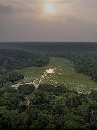
Tropical forests are essential carbon sinks, accounting for a significant portion of the Earth’s aboveground biomass and playing a vital role in global carbon cycling and climate regulation. The Lac Télé–Likouala aux Herbes protected area in the Republic of Congo, located within the Western Congolian swamp forests, is one of the most extensive and least disturbed wetland forest systems in Central Africa. Despite its ecological importance, the region faces increasing pressure from deforestation, degradation, and climate-induced disturbances. Additionally, field-based data remain sparse due to the remoteness and inaccessibility of the area.
This study leverages the power of remote sensing and spatial modeling to:
- Map and monitor land use/land cover (LULC) changes from 2018 to 2023 using Sentinel-2 multispectral imagery,
- Apply vegetation indices (e.g., NDVI, EVI, CIgreen) to enhance discrimination between forest types and degradation levels,
- Classify LULC using supervised machine learning models, including Support Vector Machines (SVM) and Random Trees (RT), to improve mapping accuracy,
- Estimate carbon storage and spatial distribution using the InVEST (Integrated Valuation of Ecosystem Services and Tradeoffs) carbon model,
- Quantify carbon stock changes over time to detect areas of loss, persistence, or potential recovery.
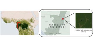
Figure 1 : Location of the study area.
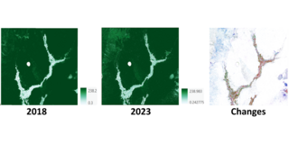
Figure 2. Carbon Storage – Spatial Distribution ((t C/ha).
This study assessed carbon storage dynamics between 2018 and 2023 in the protected area surrounding Lac Télé and Likouala aux Herbes, revealing 730.93 kha of stable land cover and 383.66 kha of change (Figure 2).
The use of Sentinel-2 imagery was central to this analysis, particularly due to the availability of SWIR bands, which enabled the calculation of key spectral indices (e.g., NDVI, NDMI, CIGreen, FDI) relevant for tropical forest health, vegetation moisture, and chlorophyll content.
Focusing on a protected area facing increasing deforestation alerts, this work highlights the value of continuous monitoring using remote sensing and the power of machine learning classifiers (SVM, RT) for land cover classification. The careful selection of ground truth data and training samples significantly improved the accuracy of LULC mapping, which is critical for estimating carbon storage.
While we used publicly available carbon datasets (ABG, BGD, SOC), the study would benefit from region-specific field measurements, particularly for belowground biomass and soil carbon.